

Weather expert forecasting 'record breaking' day as Met Eireann issue update
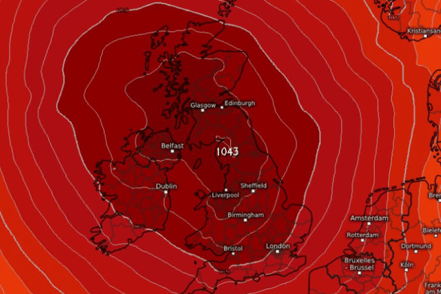

The weather forecaster is saying that ‘depending on positioning we could be close to getting a new record’
An amateur weather forecaster is suggesting that we could see a record breaking day this week.
Weather Alerts Ireland, who have accumulated hundreds of thousands of followers online, are forecasting “record breaking high pressure” to come over Ireland in the next few days.
They said that depending on the position of the high pressure, “we could be close to getting a new record”.
Their forecast reads: “Record breaking high pressure? After a few stormy days high pressure is forecast to build over the weekend and it will bring much needed settled and calmer weather to Ireland.
“The record in October in Ireland for high pressure is 1043.8hPa set back in 2018 at Sherkin Island. This high pressure is forecast to get up to 1043 and depending on positioning it could be close to getting a new record.
“Just to note high pressure does not mean warm and sunny. Depending in where it is located it can bring cloud and cold air too but it will be drier than what we have experienced over the past week. Watch this space.”
Here is Met Eireann’s updated weather forecast for the rest of the week and into the weekend:
Today: “Mostly cloudy at first with scattered outbreaks of rain. The rain will become confined to northern areas at first before clearing to isolated showers and some sunny spells through the morning. Most areas will then see a dry day with just the chance of well scattered light showers. Highest temperatures of 12 to 15 degrees with moderate to fresh southwesterly winds at first this morning, decreasing light to moderate this afternoon and becoming southerly during the evening.”
Tomorrow: “Mostly cloudy on Thursday, with isolated patches of light rain or drizzle. The best of any sunny spells will likely be in the east and north. Cloud will thicken from the west and southwest later in the evening. It'll become breezy again with a moderate to fresh southerly wind developing, strong in coastal areas. Highest temperatures of 13 to 15 degrees.”
Friday: “There is uncertainty in the forecast from Friday, but it is likely that the cloud and rain will gradually make its way further east during Friday morning. That persistent rain will generally linger over the country with the best of any drier and brighter weather towards the east coast. Highest temperatures of 13 to 15 degrees with moderate to fresh southerly winds at first, easing light and variable as the day goes on.”
Saturday: “Latest guidance suggests that Saturday morning will be cloudy and wet in the north and west, with that rain gradually moving southeastwards becoming lighter and patchier as it does so. Highest temperatures of 12 to 14 degrees in light variable winds.”
Sunday: “High pressure will start to build into Sunday, bringing mostly dry and calm conditions for Sunday, with sunny spells developing, although cloudier over the northern half of the country. A cooler day with highest temperatures of 9 to 13 degrees in a light northerly wind.”