

Weather experts forecasting 'strong storm risk' as Met Eireann issue update
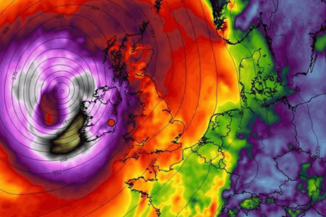

Experts are saying it will be a ‘strong enough’ storm if it hits
Weather experts are forecasting the possibility of a ‘storm risk’ next week as Met Eireann has issued an updated forecast on the matter.
Alan O’Reilly’s Carlow Weather is suggesting that Tuesday could see ‘strong enough’ storm remnants hit Ireland.
Carlow Weather, who previously have been first to the biggest weather events in Ireland in the past few years, said: “Still a lot of uncertainty around risk of storm early next week. Again the ECMWF model brings it into Ireland and strong enough into Southwest but GFS model has it peaking well South of Ireland. I’m sure you will see worst case scenario charts shared so bear in mind still very uncertain.”
While there is no exact forecast for Tuesday issued yet by Met Eireann, the national forecaster has included a little update heading into next week.
They say: “It will be unsettled for the rest of next week. There is potential for a spell of wet and windy weather on Tuesday with further spells of rain and blustery conditions possible for the latter half of the week.”
Here’s how today and the rest of the week is looking weather wise:
Thursday: “Today will be breezy. Mostly dry and cloudy to start with sunny spells in the east and patchy rain and drizzle in the west, northwest and north midlands. Cloud will thicken further across the country through the day with more persistent rain spreading over the western half of the country this afternoon and evening. Highest temperatures of 15 to 19 degrees in moderate to fresh southerly winds.”
Tonight: “Cloudy tonight with rain and drizzle spreading eastwards. Rain will clear from most areas overnight, with a few showers following. Patches of light rain and drizzle will linger in parts of the south and east until morning. Lowest temperatures of 10 to 13 degrees with southwesterly winds easing light to moderate.”
Friday: “Tomorrow morning will be cloudy with patchy rain and drizzle in the south and east and isolated showers elsewhere. It will gradually brighten up from the northwest through the day with sunny spells and isolated showers for most. However, it will remain cloudier for a time in the southeast with some drizzle patches lingering. Highest temperatures of 13 to 17 degrees in a light to moderate southwest breeze.”
Weekend overview: “Mixed conditions this weekend with showers on Saturday and more widespread rain on Sunday. Monday will be drier and brighter but it will turn more unsettled for the rest of next week.”