

Met Eireann forecast as ‘one to watch’ weather event headed towards Ireland
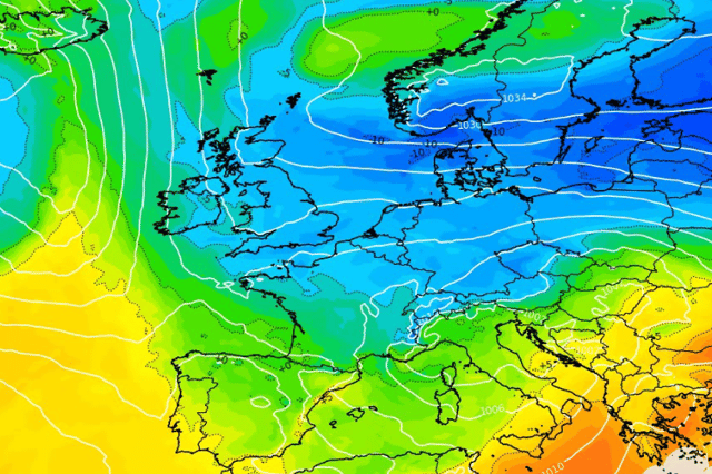

One weather forecaster said ‘nothing was written in stone yet’ but it was definitely ‘one to keep an eye on’
UK weather experts have warned about a ‘one to watch’ weather event which is heading in the direction of Ireland next week.
While Met Eireann has no long-range forecast for that long out, temperatures are expected to hit subzero at times over the rest of November with possible wintry weather on the horizon.
UK Weather Forecasts told their one million followers online that colder air could sweep over Ireland and the UK after high pressure builds which could see a significant weather event this day next week.
They said: “Could we see something colder later next week and into the final days of November? It’s worth keeping an eye on, but it’s far from set in stone.
“A lot of other weather pages are doing their usual hype, so if you’re a cold weather lover, I wouldn’t get too excited just yet. The attached GFS chart for Thursday 26th November shows one possible setup.
“If high pressure builds over Scandinavia, it could draw colder air towards us from the east or north-east. How far west that cold air gets will depend on how much of a push we see from the Atlantic. For now, I’d still favour the Atlantic. Given how much of our weather here in the UK comes from that direction, it’s hard to bet against it. One to watch, and what do I always say? More runs needed.”
Here’s the updated weather forecast for the rest of the week from Met Eireann
Today: “Any mist and fog will clear this morning, leaving a good deal of cloud for the day with scattered showers and limited bright or sunny spells. Some of the showers may be heavy with a chance of isolated thunderstorms near southern coasts. Highest temperatures of 7 to 11 degrees in light to moderate northeasterly winds, fresher near coasts.”
Thursday night: “A mix of cloud and clear spells tonight. Well scattered showers for the south and east with lowest temperatures of 2 to 7 degrees. Cooler elsewhere with isolated showers and with temperatures falling between -1 and +3 degrees. Light to moderate northeasterly winds, fresher near eastern coasts at first, will ease through the night.”
Tomorrow: “Well scattered showers in the east and southeast will clear tomorrow morning to leave a largely dry day with spells of sunshine, especially over the northern half of the country. Cloudier though for southern areas with the chance of a little drizzle in the southwest. Highest temperatures of 6 to 10 degrees, mildest in the south, in mostly light easterly or variable breezes.”
Friday night: “Largely dry and clear at first. Cloud will build from the southwest through the night with patchy light rain or drizzle developing for southwestern and western areas. Lowest temperatures of 0 to 5 degrees generally, milder in the southwest and falling below freezing in parts of Ulster, in mostly light southeasterly breezes.”
Overview: “Mixed conditions generally with rain and showers, heavy at times, especially for later Saturday and into Sunday.”