

Met Eireann weekend forecast shows sudden weather event ‘unfolding’ for Ireland

Wintry showers have been confirmed by Met Eireann also but something even bigger is being predicted by another weather forecaster
Ireland is edging closer and closer to winter each day as Met Eireann has confirmed Sunday and Monday will see possible wintry showers across the country with hail and sleet expected.
And one weather expert is predicting that a sudden weather event will also unfold for Ireland and the rest of Europe in the coming days.
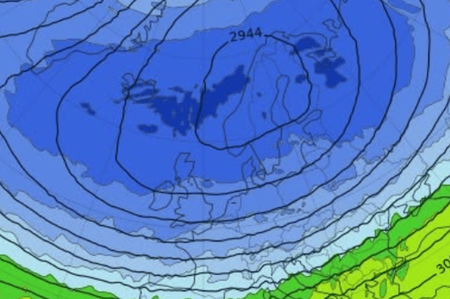
Net Weather TV, who forecast worldwide weather updates, has said that “an unprecedentedly early sudden stratospheric warming (SSW) is unfolding high above the Arctic, disrupting the polar vortex weeks earlier than ever recorded”.
The forecaster said: “All ECMWF and GEFS ensemble members confirm a wind reversal has occurred, beating the previous earliest by about 18 days. They normally occur from mid-winter.
“The reversal may 'drip' down to the troposphere later this month, which could boost high latitude blocking and the chance of cold incursions into Europe as we head into early December. Because stratospheric changes can take weeks to work downward, and this disruption is forecast to be short-lived, a deep cold and wintry spell is not guaranteed.”
Friday will see a cold start with frost gradually clearing for a mainly dry day with sunny spells and just the odd isolated shower. Temperatures of 9C will dip to as low as -1C with frost developing in some areas.
Here’s the weekend weather update in full from Met Eireann:
Overview: “Generally unsettled with outbreaks of rain and showers. Turning colder next week with the chance of some wintry showers, along with widespread frost and some icy patches by night.”
Saturday: “Tomorrow will be a cloudier day overall with occasional bright spells at first. Mostly dry to start with a few light showers but outbreaks of rain and drizzle will push into the west and southwest through the afternoon, spreading over the western half of the country by nightfall. Feeling milder with highest temperatures of 8 to 12 degrees in moderate southerly winds, freshening later.”
Saturday night: “Rain will spread eastwards to all areas early on Saturday night, becoming patchier by morning. Lowest temperatures of 4 to 8 degrees with moderate to fresh southerly winds easing light variable later.”
Sunday: “A dull start to Sunday with patchy outbreaks of rain and drizzle. Brightening up through the afternoon with sunny spells and scattered blustery showers spreading from the north. Turning breezy with moderate to fresh northwesterly winds. Highest temperatures of 8 to 12 degrees.”
Sunday night: “Mostly dry and clear overnight. However, scattered showers will affect Atlantic coastal counties, with some turning wintry in the north and northwest. Turning cold with lowest temperatures of -1 to +4 degrees, leading to widespread frost and icy patches in light to moderate westerly winds.”